
Address: Yankee Springs State Recreation Area 2104 S Briggs Rd. Middleville, MI 49333
Countie(s) trail is located in: Barry
Trail Type(s): Camping <> Cross Country Skiing <> Fishing <> Handicap Accessible <> Hiking
Trail Measurement: 0.5 Miles
If you are at the trail and this trail needs the latitude and longitude please click the link below and add it to the Add/Edit Trail Form to give us the information.
Click to view your current location on a map.
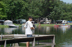
This non-motorized handicap-accessible trail connects the Gun Lake Campground with the Day Use area. Start at the campground, the trail enters a boardwalk crossing a bog area, then continues on a slag path and another boardwalk parallel with the Day Use entrance road and leads to the handicap fishing pier on Gun Lake.
If you have information about this trail please fill out the Add/Edit Trail form.
References and More Info
- Compass Latitude: 42°36’51.8″N
- Compass Longitude: 85°29’19.5″W
- Numeric Latitude: 42.614381
- Numeric Longitude: ‘-85.488739
- Elevation in Feet:
- Elevation in Meters:
- Trail Measurement: 0.5 Miles
Leave a Reply