
Address: Yankee Springs State Recreation Area 2104 S Briggs Rd Middleville, MI 49333
Countie(s) trail is located in: Barry
Trail Type(s): Camping <> Cross Country Skiing <> Hiking
Trail Measurement: 1 Mile
If you are at the trail and this trail needs the latitude and longitude please click the link below and add it to the Add/Edit Trail Form to give us the information.
Click to view your current location on a map.
The entrance location is by the Gun Lake Campground office. This is a flat wooded trail that loops back to the starting point or allows campers to connect with the Long Lake Trail at the halfway point.
More Than Just Hiking
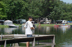
Beyond the exceptional hiking opportunities, Yankee Springs State Recreation Area offers a variety of other outdoor activities to enjoy. Anglers can cast their lines in the park’s lakes and streams, which are well-stocked with various fish species. Swimmers and sunbathers can soak up the summer sun at the designated beach areas.
For those seeking a more immersive experience, the park offers rustic cabin rentals and camping facilities, allowing visitors to truly escape the hustle and bustle of everyday life and reconnect with nature.
With its diverse trail system, stunning natural scenery, and abundance of outdoor recreation opportunities, Yankee Springs-Long Lake Trail is a must-visit destination for adventurers in western Michigan. Plan your escape to this outdoor playground today!
If you have information about this trail please fill out the Add/Edit Trail form.
References and More Info
- Compass Latitude: 42°36’51.8″N
- Compass Longitude: 85°29’19.5″W
- Numeric Latitude: 42.614381
- Numeric Longitude: ‘-85.488739
- Elevation in Feet:
- Elevation in Meters:
- Trail Measurement: 1 Mile
Leave a Reply