Address: 42.5793,-83.3598
Countie(s) trail is located in: Oakland
Trail Type(s): Cross Country Skiing <> Hiking <> Road Biking
Trail Measurement: 4.25 Miles
If you are at the trail and this trail needs the latitude and longitude please click the link below and add it to the Add/Edit Trail Form to give us the information.
Click to view your current location on a map.
West Bloomfield Woods Nature Preserve
Though it is located in a bustling suburb only 20 miles from downtown Detroit, this beautiful 162-acre site could easily be mistaken for northern Michigan. Rolling hills covered with stately oak and hickory trees lead down into bottomland forests and wetland areas. In the spring, there are great carpets of white trillium and yellow trout lilies. The site is also home to large black walnut trees and beautiful native dogwoods. The nature preserve is the western trailhead of the West Bloomfield Trail Network, a 4.25-mile rails-to-trails project that meanders through areas of wildflowers, wetlands, woodlands, and residential communities. Bicycles are allowed on the trail network only.
Wildlife Viewing
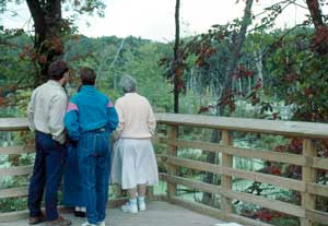
The primary attraction of this site is the active great blue heron rookery, which is easily visible near the west end of the trail network. The rookery overlook features a permanently mounted telescope for close-up viewing of approximately 100 great blue heron nests. Courtship begins in March and the nesting activity continues until the young leave the nesting area in early July. A 2.5-mile trail (1/2 mile of which is barrier-free) wanders through the glacially sculpted hills and valleys of the nature preserve, which is frequented by over 100 bird species, white-tail deer, red fox, coyote, and weasels. Sightings of soaring turkey vultures, red-tailed hawks, and osprey are no longer rare.
Directions
From Detroit, drive north on I-75 to I-696. Take I-696 west to the Orchard Lake Road exit. Turn north and drive about six miles to Pontiac Trail. Turn left (west) and continue about 1.5 miles to Arrowhead Road. Turn left (south) and proceed about ½ mile to the preserve entrance on the left.
Ownership: West Bloomfield Parks and Recreation Commission, 4640 Walnut Lake Road, West Bloomfield, MI 48323 Phone: 248-738-2500.
Size: 162 acres
Closest Town: West Bloomfield Township
If you have information about this trail please fill out the Add/Edit Trail form.
References and More Info
- Michigan DNR
- Compass Latitude: 42° 34′ 45.48″ N
- Compass Longitude: 83° 21′ 35.28″ W
- Numeric Latitude: 42.5793
- Numeric Longitude: ‘-83.3598
- Elevation in Feet:
- Elevation in Meters:
- Trail Measurement: 4.25 Miles
Leave a Reply