Address: Tawas Point State Park 686 Tawas Beach Rd East Tawas, MI 48730
Countie(s) trail is located in: Iosco
Trail Type(s): Camping <> Cross Country Skiing <> Fishing <> Hiking <> Leashed Dogs Allowed <> Swimming
Trail Measurement: 183 acres
If you are at the trail and this trail needs the latitude and longitude please click the link below and add it to the Add/Edit Trail Form to give us the information.
Click to view your current location on a map.
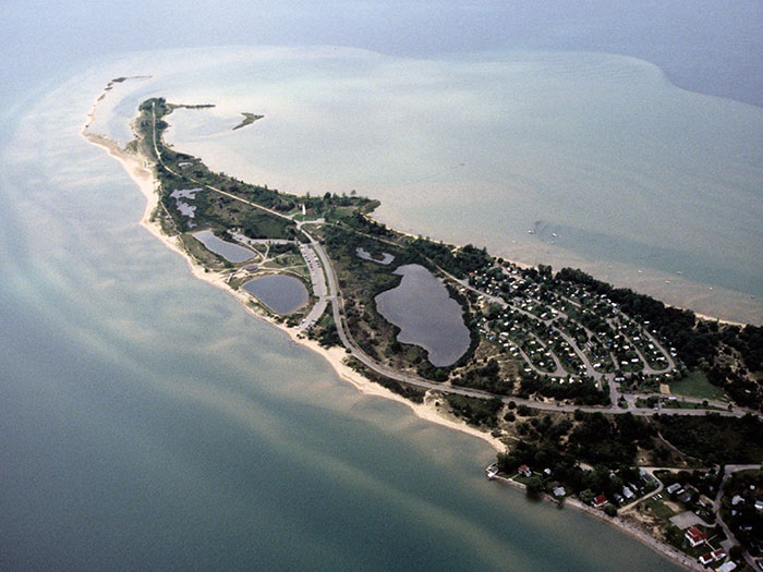
Tawas Point State Park is a Michigan state park located in Northern Michigan near the city of East Tawas. It is just over an hour’s drive from the Saginaw and Bay City area and a little over three hours from the Detroit area. The park contains 183 acres (0.74 km2) situated on the end of a sand spit that forms Tawas Bay. It has been referred to as the “Cape Cod of the Midwest.” The campground is located on Tawas Bay where the water is shallow and warm for swimming. Located within the park is the Tawas Point Light. Although it has been remodeled several times, the station serves as the sole representative of a true Victorian-era style station built on the Great Lakes. The Lighthouse is now open for tours and climbing with a small gift shop on-site; it is also possible to stay in the keeper’s quarters.
The park is located along the Lake Huron Flyway. This is considered to be an especially good locale for birding. It is said to be the most important “migrant trap” in the Saginaw Bay area, and 297 species have been seen in and around the park. A fairly complete list of migratory birds that frequent the area is available. Described as a “bird watchers’ paradise,” it has also been officially recognized as an important bird area by the National Audubon Society because it supports an incredible diversity and abundance of passerine migrants each spring and fall.”
Tawas Point Celebration Days is a family-oriented celebration of American heritage held the second weekend in June. There are many activities, including historical and educational displays, lighthouse tours, demonstrations of traditional crafts (e.g., blacksmithing, children’s activities, fishing derby, guided hikes, muzzleloader demonstrations, period encampments with reenactors in period dress, spinning, traditional music, weaving, and wood carving. The weekend is sponsored by the Friends of Tawas Point State Park.
True to its name, this site sits on a point that sticks out into Lake Huron. Narrow, sandy beaches line both sides of the point and an interpretive trail runs from the campground to the tip of the point.
Wildlife Viewing
Because it sticks out from the surrounding shoreline, Tawas Point is attractive to waterfowl and shorebirds. See large concentrations of these birds from early March through May. Watch the Lake Huron side of the point for shorebirds and the Tawas Bayside for waterfowl. During May, you may also see other kinds of birds migrating north including broad-winged hawks, turkey vultures, warblers, and blue jays. But birds are not the only kinds of animals that migrate. In mid-August, monarch butterflies often congregate on the Point to rest as they make their annual journey south to Mexico for the winter.
Directions
From East, Tawas take US-23 north one mile to Tawas Beach Road. Turn right (east) and proceed about 2.5 miles to the park entrance on the right side of the road.
Ownership: Michigan Department of Natural Resources
Size: 200 acres
Closest Town: East Tawas
References and More Info
Leave a Reply