Tag: Hiking
-

The Meadows Ski Trail
Address: 45.1586111,-84.9305556Countie(s) trail is located in: OttawaTrail Type(s): Downhill SkiingTrail Measurement:If you are at the trail and this trail needs the latitude and longitude please click the link below and add it to the Add/Edit Trail Form to give us the information. Click to view your current location on a map. Discover the Meadows Ski…
-
The Rapids Ski Trail
Address: 46.0261111,-88.7013889Countie(s) trail is located in: IronTrail Type(s): Cross Country Skiing <> Hiking <> SnowshoeTrail Measurement: 10 MilesIf you are at the trail and this trail needs the latitude and longitude please click the link below and add it to the Add/Edit Trail Form to give us the information. Click to view your current location…
-
The Ridge Ski Trail
Address: 45.4666667,-84.8988889Countie(s) trail is located in: OtsegoTrail Type(s): Downhill Skiing <> Cross Country Skiing <> Snowshoe <> HikingTrail Measurement: 5 MilesIf you are at the trail and this trail needs the latitude and longitude please click the link below and add it to the Add/Edit Trail Form to give us the information. Click to view…
-
Thor Chute Ski Trail
Address: 44.5219444,-85.9919444Countie(s) trail is located in: BenzieTrail Type(s): Downhill Skiing <> Snowshoeing <> HikingTrail Measurement:If you are at the trail and this trail needs the latitude and longitude please click the link below and add it to the Add/Edit Trail Form to give us the information. Click to view your current location on a map.…
-
Superpipe Ski Trail
Address: 45.3148,-85.6024Countie(s) trail is located in: EmmetTrail Type(s): Downhill Skiing <> Hiking <> Snowboarding <> Freestyle SkiingTrail Measurement: 2.5 MilesIf you are at the trail and this trail needs the latitude and longitude please click the link below and add it to the Add/Edit Trail Form to give us the information. Click to view your…
-
Sylvan Solace
Address: Sylvan Solace Preserve W Pickard Rd Mt Pleasant, MI 48858Countie(s) trail is located in: IsabellaTrail Type(s): Cross Country Skiing <> HikingTrail Measurement: Trail: 1.4 Miles & Area: 78 acresIf you are at the trail and this trail needs the latitude and longitude please click the link below and add it to the Add/Edit Trail…
-
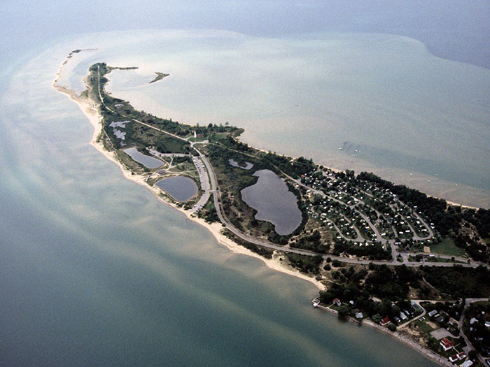
Tawas Point State Park
Address: Tawas Point State Park 686 Tawas Beach Rd East Tawas, MI 48730Countie(s) trail is located in: IoscoTrail Type(s): Camping <> Cross Country Skiing <> Fishing <> Hiking <> Leashed Dogs Allowed <> SwimmingTrail Measurement: 183 acresIf you are at the trail and this trail needs the latitude and longitude please click the link below…
-
Tawas Point-Sandy Hook Nature Trail
Address: 44.2760,-83.4380Countie(s) trail is located in: IoscoTrail Type(s): Cross Country Skiing <> Hiking <> Mountain Biking <> Road BikingTrail Measurement: 1.6 MilesIf you are at the trail and this trail needs the latitude and longitude please click the link below and add it to the Add/Edit Trail Form to give us the information. Click to…
-
Te-Bowl Ski Trail
Address: 45.1647222,-84.9422222Countie(s) trail is located in: CharlevoixTrail Type(s): Downhill Skiing <> Hiking <> SnowboardingTrail Measurement: 0.22 MilesIf you are at the trail and this trail needs the latitude and longitude please click the link below and add it to the Add/Edit Trail Form to give us the information. Click to view your current location on…
-

South Manitou Island
Trail Map Address: South Manitou Island Glen Arbor, MICountie(s) trail is located in: LeelanauTrail Type(s): HikingTrail Measurement: Trails: 7 Miles & Area: 8.2 Square MilesIf you are at the trail and this trail needs the latitude and longitude please click the link below and add it to the Add/Edit Trail Form to give us the…