
Address: Proud Lake State Recreation Area 3500 Wixom Rd Commerce Charter Township, MI 48382
Countie(s) trail is located in: Oakland
Trail Type(s): Camping <> Cross Country Skiing <> Fishing <> Hiking <> Horseback/Equestrian <> Mountain Biking <> Swimming <> Canoe/Kayak
Trail Measurement: Trails: Over 20 Miles & Area: 4,700 Acres
If you are at the trail and this trail needs the latitude and longitude please click the link below and add it to the Add/Edit Trail Form to give us the information.
Click to view your current location on a map.
Recreation Passport Required: Yes
Approximate Size: 4700 (Acres)
Proud Lake Recreation Area is located on the scenic Huron River and offers diverse and plentiful recreational opportunities. More than 20 miles of trails cover several diverse habitats. It also offers the unique River Hawk Lodge.
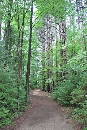
Proud Lake Recreation Area, with more than 4,700 acres, is located on the scenic Huron River in Oakland County and offers diverse and plentiful recreational opportunities. More than 20 miles of trails cover several diverse habitats. During the winter months, skiers can enjoy seeing the evergreens draped with snow. In the spring, hepatica, marsh marigold, violets, and many other wildflowers abound. Guided interpretive walks and other nature activities are offered. A schedule of upcoming programs is available at the park office year-round or at the campground office during the summer months.
Proud Lake Recreation Area, located in Commerce Township, Oakland County, near Wixom, Michigan, is a state park under the jurisdiction of the Michigan Department of Natural Resources. The recreation area has a total area of 4,700 acres (19 km2) and it offers various outdoor activities including hiking among 20 miles (32 km) of hiking trails (9 miles of which are open to horses and mountain bikes), cross-country skiing, fishing in the Huron River, hunting (in limited areas), canoeing, and picnicking. A campground has 130 campsites and a 24-person cabin for rent.
Trail Distance:
Over 20 miles long with many loops ranging in size from 0.5 to 15 miles long.
Directions:
- To Headquarters – From I-96 exit 159 follow Wixom Rd. N. 7 miles.
- To Campground – From I-96 Exit 159 follow Wixom Road N. 6 Miles. At the traffic light turn right (east) onto Glengary. The campground is approx. 1 mile on the left.
Trail List:
- Marsh Trail – 1 mile
- Blue Trail – 4.75 miles
- Red Trail – 3.75 miles
- Green Trail – 2.5 miles
- Powers Beach Trail – 1 mile
- Proud Lake–Equestrian/Biking – 8.83 (Miles), Bridle, Mountain Biking
- Bridle Trails – Trails may have other designated uses. These trails are located west of Wixom Road and are shared with mountain biking. (Phone Number: 248-685-2433)
- Proud Lake-Hiking/Skiing – 6.07 (Miles), Hiking, Cross Country Ski
- Two sections of these trails run parallel to the Huron River while another section loops around a marshy area and provides excellent wildlife viewing opportunities. (Phone Number: 248-685-2433)
- Chief Pontiac Trail – 5.5 miles
- Service Road Trail – 1.5 miles
Campgrounds
Proud Lake-Camper Cabin
(800) 447-2757
2 site(s), $86, $65 (off-season)
Electrical Service
Proud Lake-Group Use Area
(248) 685-2433
0 site(s), Contact the park
Group Use Area, Walk-in Sites
Proud Lake-Modern
(800) 447-2757
130 site(s), $25 (50A), $23 (20/30A)
Boat Launch, Electrical Service, Mini Cabin, Modern Restrooms, Some Campsites with 50 amp Service, Swimming
If you have information about this trail please fill out the Add/Edit Trail form.
References and More Info
- Compass Latitude: 42°34’16.2″N
- Compass Longitude: 83°33’17.9″W
- Numeric Latitude: 42.571161
- Numeric Longitude: ‘-83.554974
- Elevation in Feet:
- Elevation in Meters:
- Trail Measurement: Trails: Over 20 Miles & Area: 4,700 Acres
Leave a Reply