
Address: 43.220407, -85.202720
Countie(s) trail is located in: Gratiot <> Montcalm
Trail Type(s): Cross Country Skiing <> Hiking <> Inline Skating <> Mountain Biking <> Road Biking
Trail Measurement: 41.8 Miles
If you are at the trail and this trail needs the latitude and longitude please click the link below and add it to the Add/Edit Trail Form to give us the information.
Click to view your current location on a map.
End Points
- 43.220407, -85.202720
- 43.376615, -84.663519
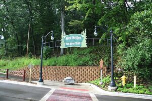
Greenville has a well-developed trail system. The eight-mile-long Fred Meijer Flat River Trail connects Greenville’s major parks and circumnavigates the city. Greenville is also the terminus of the 41 miles long Fred Meijer Heartland Trail. This trail connects Greenville to Alma and various other communities in Montcalm and Gratiot counties. Mountain biking is available at both the Shearer Road and Edward’s Creek mountain bike paths.
References and More Info
- Wikipedia
- Compass Latitude: 43°13’13.5″N
- Compass Longitude: 85°12’09.8″W
- Numeric Latitude: 43.220407
- Numeric Longitude: ‘-85.202720
- Elevation in Feet:
- Elevation in Meters:
- Trail Measurement: 41.8 Miles
Leave a Reply