Address: Dowagiac Woods Pokagon, MI 49047
Countie(s) trail is located in: Cass
Trail Type(s): Hiking
Trail Measurement: Trail: 2.5 Miles & Area: 384 Acres
If you are at the trail and this trail needs the latitude and longitude please click the link below and add it to the Add/Edit Trail Form to give us the information.
Click to view your current location on a map.

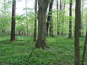
Dowagiac Woods Nature Sanctuary, commonly referred to as Dowagiac Woods, is a 384-acre (155 ha) woods located in Cass County, Michigan. It is maintained and preserved by the Michigan Nature Association which is a non-profit organization dedicated to protecting Michigan’s exceptional natural habitats and extraordinary and endangered plants and animals.
About the Sanctuary
Plants flourish at Dowagiac Woods in countless numbers. Over fifty species of wildflowers bloom in the spring. After the first flowers open, hepatica and bloodroot start, quickly followed by a profusion of blooming that continues right up through the time of Trillium grandiflorum. The tulip tree occurs in great numbers in the central forest, which is on slightly higher ground than the lowlands. Buds of the tulip tree unfold early.
A top attraction in the Dowagiac Woods Nature Sanctuary is the abundance of blue-eyed Mary, Collinsia verna. For six full weeks, beginning early in April, it reigns supreme. Over 150 beds can be seen from the trail, each averaging ten by twenty feet square.
Nearly fifty kinds of trees have been found at Dowagiac Woods Nature Sanctuary, including blue beech, black ash, black walnut and hackberry. The Ohio buckeye also thrives here in all sizes, from seedlings to one very tall tree that two people can scarcely reach around. The buckeye is the first tree to leaf out in the spring and blooms in late April.
Dowagiac Woods Nature Sanctuary is also home to many animals, including at least 49 different kinds of birds. The songs of the yellow warbler, Acadian flycatcher and ruffed grouse can all be heard.
References and More Info
- Wikipedia
- Compass Latitude: 41°58’34.2″N
- Compass Longitude: 86°10’48.8″W
- Numeric Latitude: 41.9761804
- Numeric Longitude: ‘-86.180234
- Elevation in Feet:
- Elevation in Meters:
- Trail Measurement: Trail: 2.5 Miles & Area: 384 Acres
Leave a Reply