Address: Fishermans Island State Park 16480 Bells Bay Rd Charlevoix, MI 49720
Countie(s) trail is located in: Charlevoix
Trail Type(s): Camping <> Cross Country Skiing <> Hiking <> Mountain Biking <> Swimming
Trail Measurement: 2,678 Acres
If you are at the trail and this trail needs the latitude and longitude please click the link below and add it to the Add/Edit Trail Form to give us the information.
Click to view your current location on a map.
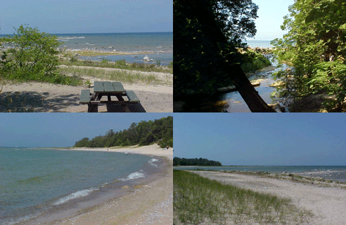
Fisherman’s Island State Park boasts over six miles of unspoiled Lake Michigan shoreline. The island in which the park was named no longer exists. Due to years of lower water levels in Lake Michigan the island has become a peninsula now lush with native wildflowers. There are 80 rustic campsites with 15 of those nestled in the dune area along the Lake Michigan shoreline.
Fisherman’s Island State Park is not actually an island, but a 2,678-acre park. The interior terrain consists of rolling dunes covered with maple, birch and aspen broken up by bogs of cedar and black spruce.
Trails
Fisherman’s Island-Foot Trail
Trail Length in Miles: 3.00 (Miles)
Hiking
Campgrounds
Fisherman’s Island-Rustic
81 site(s)
Rustic Site, Vault Toilet
The former island is located a short distance from the picnic area. The park features a rustic campground with some of the sites nestled in the dunes along the lake shore. The park road travels through the campground to the picnic area with access to the beach and 3 miles of hiking trails. The interior terrain consists of rolling dunes covered with maple, birch and aspen broken up by bogs of cedar and black spruce. The park is open May 16 to November 16 and is maintained and operated by the Michigan Department of Natural Resources.
Facilities and activities
- Swimming
- Picnicking
- Hiking
- Camping: The camping area is divided into a north and south loop and has 81 sites and 6 vault toilets.
- Cross-country skiing
- Hunting
References and More Info


Leave a Reply