Address: 1715 Hillburn Avenue NW, Grand Rapids, Michigan 49504
Countie(s) trail is located in: Kent
Trail Type(s): Cross Country Skiing <> Hiking
Trail Measurement: Trail: 4 Miles & Area: 143 acres
If you are at the trail and this trail needs the latitude and longitude please click the link below and add it to the Add/Edit Trail Form to give us the information.
Click to view your current location on a map.
Trail Map

This site contains a diverse mixture of rolling hardwood forest, streams, ponds, wetlands, and old farm fields just minutes from downtown Grand Rapids. Hiking trails wind throughout all of the habitats found on this 143-acre preserve. Portions of the trail are barrier-free.
Wildlife Viewing
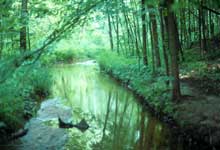
A great place to see birds, mammals, and amphibians of Michigan from groomed trails and boardwalks traversing a hardwood forest and former farmland. An observation deck overlooks a woodland stream in a ravine, and a tall observation tower gives a bird’s eye view of a pond and wetlands. Blandford staff often offer guided walks to see owls, bats, frogs, toads, turtles, snakes, and animal tracks. The evening “Owl Prowls” is very popular in the fall. Forested portions of the preserve offer magnificent wildflower viewing, including trilliums, while a chorus of frogs and spring peepers add charming background music. Blandford also has an active wildlife rehabilitation clinic, with many permanent wild residents on public display in outside enclosures, including owls, turkey vultures, a fox, and more.
Directions
From US-131 in Grand Rapids, take the Leonard Street exit and travel west for about 3-1/2 miles to Hillburn. Turn right (north) on Hillburn to reach the nature center at the end of the street.
Size: 143 acres
Closest Town: Grand Rapids
Facilities and Opportunities:
- Restrooms – At the Visitor Center.
- Trails – Open every day from dawn to dusk.
- Picnic Visitor Center
- Drinking-Water – At the Visitor Center.
- Barrier-Free – Visitor Center and portions of the trails.
References and More Info
- DNR
- Compass Latitude: 42°59’48.1″N
- Compass Longitude: 85°44’22.6″W
- Numeric Latitude: 42.9966894
- Numeric Longitude: ‘-85.7396152
- Elevation in Feet:
- Elevation in Meters:
- Trail Measurement: Trail: 4 Miles & Area: 143 acres


Leave a Reply