Address: 42.7862,-83.626083
Countie(s) trail is located in: Genesee <> Oakland
Trail Type(s): Canoe/Kayak <> Fishing
Trail Measurement: 7 Miles
If you are at the trail and this trail needs the latitude and longitude please click the link below and add it to the Add/Edit Trail Form to give us the information.
Click to view your current location on a map.
Trail Map 1 <> Trail Map 2 <> Trail Map 3 <> Trail Map 4
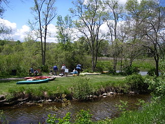
Paddle Your Way to Adventure
The Shiawassee River Heritage Water Trail is a paddler’s paradise, perfect for both novice and experienced water sports enthusiasts. Here are some of the top activities you can enjoy:
1. Kayaking
Glide through the gentle currents of the Shiawassee River in your kayak, taking in the breathtaking scenery that surrounds you. The trail offers varying water conditions, from calm stretches perfect for beginners to more challenging sections that will thrill experienced kayakers.
Pro Tip: Bring a waterproof camera to capture the stunning vistas and wildlife you’ll encounter along the way.
2. Canoeing
For those who prefer a classic river experience, canoeing on the Shiawassee is an absolute must. Whether you’re planning a solo trip or a group adventure, the river’s diverse landscapes provide an ideal backdrop for a memorable canoeing excursion.
3. Fishing
Anglers, rejoice! The Shiawassee River is teeming with a variety of fish species, making it a prime spot for fishing enthusiasts. Cast your line and try your luck at catching smallmouth bass, northern pike, or even the elusive steelhead during their seasonal runs.
Fishing Tip: Check local regulations and obtain necessary permits before your fishing trip.
Trail Details: A Journey Through Nature
While specific information about the trail’s length and difficulty is limited, the Shiawassee River Heritage Water Trail offers a diverse experience for paddlers of all skill levels. The river meanders through a mix of urban and rural landscapes, providing a unique perspective on Michigan’s natural beauty.
As you navigate the trail, you’ll encounter:
- Scenic woodlands teeming with wildlife
- Peaceful wetlands home to diverse bird species
- Historic bridges and structures that tell the story of the region
- Occasional rapids that add a touch of excitement to your journey
Remember to plan your trip according to your skill level and the current water conditions. Always prioritize safety and be prepared for changing weather patterns.
Explore Nearby Attractions
The Shiawassee River Heritage Water Trail is surrounded by a wealth of attractions in Genesee and Oakland counties. After your water adventure, consider exploring:
- Stepping Stone Falls: Located near Flint, this man-made waterfall offers a picturesque spot for picnics and photography.
- Seven Lakes State Park: Just a short drive from the trail, this park offers additional water activities, hiking trails, and camping facilities.
- Crossroads Village & Huckleberry Railroad: Step back in time at this historic village and enjoy a scenic train ride along the shores of Mott Lake.
- Downtown Fenton: Explore charming local shops, restaurants, and breweries in this vibrant community near the trail.
Your Shiawassee River Adventure Awaits!
The Shiawassee River Heritage Water Trail is more than just a waterway – it’s a gateway to unforgettable experiences and natural wonders. Whether you’re seeking a peaceful paddle, an exciting fishing expedition, or a chance to connect with nature, this trail has something for everyone.
So, grab your paddle, pack your sense of adventure, and set out to explore the hidden treasures of the Shiawassee River Heritage Water Trail. Your next great Michigan adventure is just a paddle stroke away!
Note: Always check current water conditions, obtain necessary permits, and follow local guidelines for a safe and enjoyable experience on the Shiawassee River Heritage Water
The Shiawassee River Heritage Water Trail is a 7 miles (11 km) water trail in the Shiawassee River, within Genesee County and Oakland County, Metro Detroit, southeastern Michigan.
The 7 miles (11 km) water trail in the Shiawassee River begins in Holly, Michigan at WaterWorks Park and extends seven miles downstream to Strom Park in Fenton, Michigan. There are signs that discuss the trail, its history, and what to expect along the trail.
The City of Fenton maintains a boat launch at Strom Park. From there, one has to portage around the Fenton Mill Pond Dam. The Keepers of the Shiawassee in cooperation with the City of Fenton Parks Commission has built a canoe launch in Bush Park. From Bush Park downstream, the next official take out is the Michigan Department of Natural Resources’s boat launch in Lake Ponemah. The City of Linden has a take out above the Linden Mill Pond Dam and a put in just below it, with a path to use for portaging around the dam.
The trail continues to be extended every year as the University of Michigan-Flint’s University Outreach program continues to work with local governments to take an active role in protecting natural infrastructures such as rivers and streams.
Trail Distance:
- Sites 1-3 (7 miles)
- Sites 4-7 (7 miles)
- Sites 7-9 (5 miles)
- Sites 10-11 (4 miles)
- Sites 11-12 (7 miles)
Trail Difficulty:
Moderate
Trail Description:
The Shiawassee River is a shallow, slow-moving stream that features an “Up North-Close by” view of nature starting from the old waterworks building in the Village of Holly and traveling seven river miles downstream through an unspoiled natural landscape to Strom Park in the City of Fenton. Travel another seven miles downriver as it continues to wind through Fenton’s parks, Lake Ponemah, Tupper Lake, and Linden Mill Pond. The river becomes more secluded and wild past Historic Linden wondering for eight miles through wetlands and woods into Argentine.
Download the information pamphlet on Shiawassee River Water Trail
Click here to read more information about this trail and surrounding areas
Click here to read more information about the river and another map
References and More Info
- Wikipedia
- Compass Latitude: 42°47’10.3″N
- Compass Longitude: 83°37’33.9″W
- Numeric Latitude: 42.7862
- Numeric Longitude: ‘-83.626083
- Elevation in Feet:
- Elevation in Meters:
- Trail Measurement: 7 Miles
Leave a Reply